Geología de la Antártida
Argentina
Geological Evolution Of The Transantarctic
Mountains, Southern Victoria Land, Antarctica.
History Of Exploration
In late 1839-early 1840 Capt James Clark Ross in charge of two vessels, HMS
Terror and HMS Erebus, sailed south from Hobart with the aims of recording
magnetic observations at high southern latitudes and, if feasible, of reaching
the South Magnetic Pole. Ross sighted land near Cape Adare in Northern Victoria
Land (NVL), and observed the high peaks of the Transantarctic Mountains (TAM).
He collected geological specimens from offshore islands, and sailed south into
the Ross Sea, to the foot of Mt Erebus and the barrier of the Ross Ice Shelf.
Whaling expeditions were to follow in subsequent years.
In 1899, a British-sponsored expedition, led by an Australian Carstens
Borchgrevink, wintered over in NVL, and next year, on the Southern Cross sailed
south to Ross Island, collecting samples of Tertiary volcanic rocks en route.
The major geological advances in SVL, however, were made in later expeditions
led by Scott and Shackleton, first in 1901-4 on Discovery, then in 1907-9 on
Nimrod, and finally the ill-fated Terra Nova expedition of 1910-13. As you all
doubtless remember, it was Scott's insistence on retaining rock specimens
collected on his return from the South Pole that may have contributed to his
demise. I sympathise with his dilemma, all of the Otago field seasons have
involved either the back-packing or man-hauling by sledge of rock specimens,
with a constant temptation to offload surplus specimens into the nearest
crevasse!
Geological Summary
So what of the geology of the Transantarctic Mountains? The mountain range
itself extends across the Antarctic continent for a distance in excess of 3500
km, and comprises peaks over 4000 m high. One of the lasting impressions of SVL
is the view from near Ross Island, where Scott Base and McMurdo Base are
situated, of the majesty of the Transantarctic Mountains rising steeply from the
Ross Ice Shelf. This segment of the TAM was named by Scott's party as the Royal
Society Range, in recognition of the financial support for the expedition; many
of the peaks carry the names of past presidents of that society.
 The
Transantarctic Mountains divide Antarctica into two geological provinces. East
Antarctica, the larger of the two, is geologically a very stable area, composed
of very old rocks, which we refer to as a craton. In SVL, most of the craton is
covered by ice of the Polar Plateau, but elsewhere the rocks have been dated as
Archean, extending back in time to 2.5 Ga (2,500,000,000 years). In contrast,
West Antarctica is composed of a collage of crustal segments, unrelated to the
craton, and much younger. Effectively the TAM is a suture, dividing yet uniting
the continent.
The
Transantarctic Mountains divide Antarctica into two geological provinces. East
Antarctica, the larger of the two, is geologically a very stable area, composed
of very old rocks, which we refer to as a craton. In SVL, most of the craton is
covered by ice of the Polar Plateau, but elsewhere the rocks have been dated as
Archean, extending back in time to 2.5 Ga (2,500,000,000 years). In contrast,
West Antarctica is composed of a collage of crustal segments, unrelated to the
craton, and much younger. Effectively the TAM is a suture, dividing yet uniting
the continent.
To answer the question of how the TAM was formed, we need to go back
approximately 750 million years into the Precambrian period and then, according
to ideas espoused by Moores and Dalziel, the East Antarctic craton used to form
the nucleus of a land mass called Rodinia. Their idea, referred to as the SWEAT
hypothesis, derives from SouthWestern U.S. East Antarctica, since the proponents
believe that the best correlation of rocks from the margin of East Antarctica
lie along the margin of the Laurentian craton of North America.
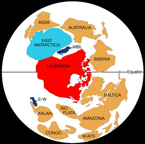 |
 |
| Fig. 2.A Reconstruction of the supercontinent
Rodinia at ca 725 Ma (E-W- Ellsworth Whitmore, W.AFR-West African craton,
KALAH-Kalahari craton). |
Fig. 2B. Reconstruction of Rodinia at the
Cambrian-Precambrian boundary, showing subduction of the Paleo-Pacific
ocean crust at the Delamerian-Ross convergent margin (S.FR-Sao Francisco
craton, SIB-Siberia craton)
|
Acceptance of mobility of crustal
fragments around the surface of the globe, undreamt of in Scott's time, or even
in the early years when I trained as a geologist (!), was made possible through
the revolutionary Plate Tectonic concept. Rodinia is thought to have fragmented
approximately 700 million years ago, North America drifting off to its place on
the surface of the Earth, opening up an expanding ocean, the fore-runner of the
Pacific Ocean perhaps, in its wake. Evidence for an old oceanic component on the
edge of East Antarctica lies in suite of basalts of mid-ocean ridge character,
dated at 668 Ma, now incorporated into the central sector of the Transantarctic
Mountains.
Subsequently, with successive plate readjustments, the paleo-Pacific Ocean
closed, and the rifted margin of East Antarctica became a war zone. Here oceanic
crust of the newly-opened Pacific Ocean was destroyed by subduction and any
crustal fragments adrift in the ocean were rafted towards the subduction zone to
collide with, and be accreted onto, the leading edge of the craton. Plate
convergence, with associated subduction and collision, was responsible for
uniting East and West Antarctica. The association of geological processes is
referred to as the Ross Orogeny. An orogeny is a mountain building process, a
time when there is upheaval of the earth's crust, with associated magmatic
activity and metamorphism of any sediments that had formed in the ocean basin,
or along its margin, and which were deformed and thermally altered on
incorporation into the convergent plate margin. This convergence, occurring in
latest Precambrian or Cambrian times, approximately 500 million years ago, is
not unique to Antarctica. The same aged orogenic rocks occur in New Zealand (as
part of Fiordland), and in Australia. The inescapable conclusion from these
correlations is that Antarctica, New Zealand and Australia used to be part of
the same margin, they were part of a single supercontinent, which is called
Gondwanaland. Africa, South America, and India were also our neighbours.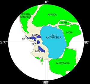
It
is these Ross Orogeny rocks that were later to become the so-called basement to
the TAM. They are the oldest rocks exposed over much of the mountain range, and
they have been uplifted, eroded, subjected to later orogenies, and overlain by
later rocks.
Throughout SVL the Ross Orogeny basement rocks have been eroded down over a long
period of geological time (perhaps up to 100 million years), to form an almost
planar upper surface, on which later rocks have been deposited. This surface, an
unconformity, has been termed the Kukri erosion surface or peneplain. It is
overlain by a vast (c 2.5 km thick) sequence of horizontally bedded sediments,
dominated by quartz-rich alluvial sandstones and conglomerates, but containing
Carboniferous glacial deposits and Permian coal measures. Collectively the
sequence is referred to as the Beacon Supergroup (colloquially “Beacon
Sandstone”), and is interpreted as having been deposited in elongate
non-marine or at times shallow marine basins parallel to the present axis of the
TAM. In SVL its age ranges from Devonian to Triassic, a period of nearly 200 Ma.
Fossil fish and land vertebrates have been found, indicating establishment of
fresh-water lakes at various stages of the sedimentary history.
The next event recorded in the geological history of SVL occurs over the length
of the TAM and represents the intrusion of copious volumes (estimated between
1.0 and 1.7 x 10⁷ km3) of basaltic magma. This was injected into the basement
and into the overlying Beacon Sandstone. The dominant form is of subhorizontal
sheets, intruded into the basement, along the peneplain, and into the overlying
sediments, where they define bodies called sills. Occasional discordant, steeply
dipping intrusions called dykes connect the sill horizons. Individual sills
often reach thicknesses of 420 m and can be traced, or extrapolated, over very
large areas (>20000 km2). Because of the thermally insulating effect of large
magma volumes, the sills cool slowly and form rocks called dolerites, rather
than basalts. However, magmas are also injected to the Earth's surface and are
erupted as lavas that cool more slowly and form the Kirkpatrick Basalt. Recent
work within the Department has shown that some of these high level magmas react
explosively with groundwater in the Beacon Sandstone and form extensive
phreatocauldera. Basalts and dolerites are collectively referred to as the
Ferrar Supergroup, named after H.T.Ferrar, geologist on Scott's Discovery
expedition. Recent work has suggested that Ferrar magmas have such similar
compositions that they must have been generated in a single, point-source,
partial melting event in the mantle of the Weddell Sea area, and subsequently
injected and magmatically transported up to 3000 kilometres along the length of
the TAM.
Irrespective of whether the magmas are indeed far-travelled, it is clear that
Ferrar magmatism marks a very important event in terms of its distribution.
Igneous rocks have been isotopically dated, and as analytical accuracy and
precision have improved, it is evident that the copious outpourings have
occurred over a very short time frame in the Jurassic (177-183 Ma). What is
more, similar magmatism occurs elsewhere in Gondwanaland, in Africa (the Karoo
basalts), in Tasmania and New Zealand, and in the Falklands. Such Large Igneous
Provinces (LIPs) are a characteristic consequence of, or precursor to,
continental fragmentation.
In many theories, the impact of a deep mantle-generated plume or superplume onto
the lithosphere is instrumental in the break-up of a supercontinent such as
Gondwanaland. Plumes are considered to be a diapiric uprise, perhaps from the
core-mantle boundary, of a vertical column of plastic rock. When the plume
intersects the base of the lithosphere its head flattens out, dragging the
lithosphere with it, and initiating plate spreading. If a superplume was
responsible for the fragmentation of Gondwanaland, it is argued that the likely
impact site would be the area of the present Weddell Sea.
New plate boundaries were established during the dispersal of Gondwanan
fragments, but until recently there has been considerable debate about whether a
boundary still existed through the Antarctic continent. Through Deep Sea
Drilling projects, through marine geophysical investigations, and through
paleomagnetic observations we now know that the Ross Sea Embayment contains
extensive sedimentary basins that have accumulated considerable thicknesses (up
to 7 km) of Tertiary sediments. East and West Antarctica have also undergone at
least 300 km of displacement and perhaps 40° to 90° of rotation in the last
100 Ma. Recently it was established that much of this separation occurred in the
Eocene and Oligocene, related to spreading in the Adare Trough at the mouth of
the Ross Sea Embayment.
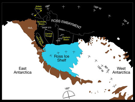 Fig.4.
The Ross Sea area showing the Transantarctic Mountains, the offshore sedimentary
basins of the Ross Embayment, and location of Eocene-Oligocene spreading in the
Adare trough.
Fig.4.
The Ross Sea area showing the Transantarctic Mountains, the offshore sedimentary
basins of the Ross Embayment, and location of Eocene-Oligocene spreading in the
Adare trough.
Fission track dating had
established many years earlier that uplift of the TAM started approximately
55 Ma ago. The documented extension and subsidence of the crust in the Ross
Embayment is compatible with complementary uplift of the Transantarctic
Mountains on the western shoulder of this rift system. As such, uplift of
the TAM occurs by normal faulting, in marked contrast to the collisional
events at convergent margins typical of other mountain belts around the
world (e.g. Himalayas, European and New Zealand Alps etc).
Extensional Tertiary sedimentary basins received the erosional debris from
the rising TAM, and the extension is also manifest in one other concurrent
geological phenomenon, namely magmatism. Volcanic rocks were erupted in NVL
from 48 Ma (Eocene) and in SVL from 24 Ma (Oligocene) to the present day. Mt
Erebus, formed as a consequence of this magmatism, is the most southerly
active volcano on Earth.
Climatic deterioration occurred in the late Tertiary, but fine details of
the glacial chronology and the extent of the glaciations are still uncertain.
Resolution of these issues is the subject of multi-national drilling
incentives (e.g. ANDRILL) at the present day. The geological history of SVL
is summarised in the attached stratigraphic column.
Geology Of Southern Victoria Land
The Otago programme investigating the basement
terrain formed during the Ross Orogeny has had to deal with a variety of mainly
plutonic igneous rocks intruding into and inducing contact metamorphism of a
metasedimentary sequence of uncertain age.
Further south, sediments include fossiliferous,
archeocyathid-bearing limestones, enabling a biostratigraphic age of Cambrian to
be assigned. In SVL the grade of metamorphism of calcareous and calc-silicate
sediments is reasonably high, and any fossils have been destroyed by metamorphic
recrystallisation. Ages of the parent rock type (protolith) are therefore
unknown.
Intrusive igneous rocks had been mapped and classified previously on the basis
of either the presence or absence of a foliation (a planar mineral fabric such
that a rock splits into parallel-sided slabs) or their colour (pink, grey,
etc.). Those granites where the individual grains have a parallel alignment to
form a foliation, were inferred to have been recrystallised by a metamorphic
event subsequent to intrusion and were designated as pre-tectonic. Those that
were non-foliated were assumed to have been unaffected by metamorphism, and
hence were post-tectonic. Unfortunately this scheme doesn't work, as our first
batch of post-graduate researchers quickly found out. The policy was adopted
instead, of mapping the basement igneous rocks as separate intrusions (or
plutons). The practice was labour intensive in the field, but using field
relationships it gave rise to an unambiguous relative age for each pluton. The
presence of fragments of one type of granite enclosed within another clearly
indicated that the fragments belonged to an earlier pluton that had been broken
off and entrained into a later intrusion. Similarly, an igneous intrusion such
as a dyke, emplaced across another igneous body is clearly later.
Geochemical analysis back in the laboratory resulted in an additional chemical
classification of the granite. These first studies, conducted on granites in the
Dry Valleys area, were instrumental in defining different igneous suites, whose
chemical characteristics were broadly compatible with formation in a convergent,
plate-margin environment, above the previously inferred subduction zone where
the paleo-Pacific Ocean crust was consumed beneath the East Antarctic craton.
As the programme evolved, it became clear that in order to make regional
correlations and to constrain the duration of the Ross Orogeny we needed
absolute ages on specific plutons in order to define the timing of intrusion of
the various suites. Given that K-Ar dating gives uplift rather than intrusive
ages, and is susceptible to resetting by subsequent thermal events, we opted to
try U-Pb dating instead, which is potentially a more robust chemical system.
U is a radioactive element, with 238U decaying with time to 206Pb,
and 235U decaying to 208Pb. U is an element that is
accommodated into the crystal structure of the mineral zircon, ZrSiO4.
Zr, in turn, is an element that occurs in some abundance in the continental
crust, so is concentrated in granitic magmas formed by melting of crustal
materials. Zircon is a highly refractory, physically resistant mineral, which,
once formed, is difficult to destroy and it requires exceedingly high
temperatures to recrystallise or modify the stored age signature within a
chemically zoned grain. Zircon is separated from crushed granites using density
and magnetic properties, and suitable grains are then chemically treated to
isolate the appropriate elemental concentrates. Isotope ratios are determined by
Thermal Ionisation Mass Spectrometry, and an age calculated. All of this U-Pb
geochronology has been undertaken in collaboration with scientists Drs Dave
Parkinson and Nick Walker who have access to overseas facilities at UCSB and
Brown University respectively.
We have also experimented with microbeam techniques for age determination,
whereby individual grains, or zones in grains are bombarded by either a laser
beam, or a beam of oxygen ions which vaporises a small area of the mineral.
Products of the vaporisation are fed directly into a mass spectrometer, where
isotope ratios are determined. The two techniques, available at the Australian
National University are referred to as ELA-ICP-MS (excimer laser ablation
induced coupled plasma mass spectrometry) and SHRIMP (sensitive high resolution
ion microprobe). Both techniques are capable of analysing separately a relict
core of a zircon grain, which might be inherited from a previous cycle of
geological events, and the latest growth around the crystal rim, which has
formed by igneous crystallisation during residence in a granitic magma chamber.
Results of the dating give intrusive igneous ages ranging from 551 Ma to 488 Ma,
with some zircons being recycled during successive melting and intrusive events.
The Ross Orogeny, therefore, occurred over an interval of time of at least 65
million years, equivalent to the time since the dinosaurs disappeared on Earth
at the end of the Cretaceous. Since many of the granites intrude previously
deformed and metamorphosed country rock materials, this figure has to be
considered as a minimum estimate for the duration of the orogeny.
The timing of metamorphism is difficult to determine directly, but it has
recently been constrained by microbeam (LAP-ICP-MS and SHRIMP) study of the ages
of detrital zircons in the metasediments. Zircon retains its early pre-metamorphic
history despite the enclosing rock recrystallising totally to a new fabric.
Sedimentary rocks accumulate detrital zircon that is washed into the basin of
sedimentation from the surrounding river catchment. These zircons will be of
varying ages, but clearly none can be younger than the age of sedimentation. The
minimum age of detrital zircon will give a minimum age for the age of
sedimentation and therefore a maximum age for the subsequent metamorphism. So
far we have only determined zircon age spectra from two metasediments from SVL,
and have minimum ages of detrital zircons of c. 630 Ma. These sediments are
likely, therefore, to be late Precambrian in age, with subsequent metamorphism
during the early Ross Orogeny, prior to the magmatic climax marked by granitoid
intrusion. We are hoping to expand the detrital zircon technique to look at the
age and regional provenance of other sediments metamorphosed during the Ross
Orogeny. This analysis will also enable us to put a maximum estimate on the
inception of the Ross Orogeny.
Pequeño resumen
sobre la Geología de la Antártida
|
| OVERVIEW
Antarctica is the southern-most continent on the Earth and the
continent that we know the least about geologically. Two factors make it
difficult to study the geology and mineral resources of Antarctica. One,
the cold temperatures and strong winds, along with the 24 hour period of
darkness during the Antarctic winter, make it a very difficult place to
work and collect geological data. Two, less than 3% of Antarctica is
ice-free, which makes the study of geology of Antarctica very difficult.
GEOLOGY AND PLATE
TECTONICS What we know about the geology of Antarctica
comes from studying the small percentage of the rocks that are exposed
either at the coast or the tops of mountain ranges which extend above
the ice. Our understanding of the geology of the Antarctic region is
based on the theory of plate tectonics.
Plate tectonics is the theory that the
earth's crust is made up of a series of pieces. Each piece is called a
plate. These plates float on top of the semi-fluid mantle like rafts.
The mantle is believed to have convection cells within it which move
these plates around. Because of the theory of plate tectonics, most
geologists believe that up until about 180 million years ago, South
America, Africa, India, Australia, and New Zealand were all joined
together in one very large mass called Gondwana. One piece of evidence
that supports the idea of this large land mass is that all of these
continents fit together like a jigsaw puzzle. It has also been found
that when these continents are placed together they share matching
fossils, rock types, and land features. The best explanation for this
similarity is that the rocks, fossils and land features formed when the
continents were joined together.
When Gondwana started to break up, the
land masses gradually moved into the positions that we see them today.
This idea that all the land masses were formed together allows us to
make some assumptions about the geology of Antarctica even though very
little of the crust of Antarctica is exposed.
The continent of Antarctica is divided
into two large geologic areas -- East and West Antarctica. East
Antarctica is the large bean-shaped land mass centered on 90 degrees
east longitude. West Antarctica is the area centered on 90 degrees west
longitude and includes the Antarctic Peninsula, Marie Byrd Lane, and the
area east and north of the Transantarctic Mountains. Because of the
thick ice sheet, geologic details are not possible to obtain for all of
Antarctica, an area the size of the United States and Mexico combined.
East Antarctica is a large Precambrian
shield, a stable portion of a continent composed of old rocks that have
changed very little over a long time. It is similar to shield areas in
Brazil, Africa, India, and Australia. The oldest rocks found in this
area are over 3 billion years old. These rocks are metamorphic rocks
overlaid by younger, flat-lying ocean-deposited sediment. High-grade
METAMORPHIC ROCKS dominate the coast.
The Ross mobile belt, a major tectonic
unit, includes the Transantarctic Mountains. An inner belt of
sedimentary and volcanic rocks of the Gondwana System are Devonian to
Jurassic in age; an outer belt is Precambrian to Cambrian in age.
Cenozoic volcanic rocks, mainly basaltic, are present on the west side
of the Ross Sea. The rocks were recrystallized during an orogeny, a
mountain building episode caused by plate collisions, in the early
Paleozoic Era (about 500 million years ago). Typical samples would
probably include gneiss, schist, granitics, shale, sandstone, and
limestone. The land of East Antarctica is low in elevation with large
bays indenting the coastline. The weight of the thick ice sheet has
pushed the land down so far that if it were removed, the land would
rebound nearly 2,000 feet.
East Antarctica was part of Gondwana, the
large, single, land mass made up of the present continents of South
America, Africa, India, Australia, and Antarctica. Gondwana existed as
far back as 1 billion years ago and moved and rotated in the southern
hemisphere as a unit until about 200 million years ago when it began to
break up and finally broke apart from present land masses about 40
million years ago. Gondwana was part of Pangaea, the supercontinent made
up of all the major continents in the Paleozoic Era.
West Antarctica is a more recent addition
to the continent. It was built up over the last 500 million years by the
addition of small continental fragments (called microplates), four of
which have been identified. They include the Ellsworth Mountains block,
the Antarctic Peninsula, an unnamed block of igneous rocks and
metamorphosed sediments, and the Marie Byrd Land block. The collisions
that added these microplates to Antarctica have built up the mountains
of West Antarctica. Unlike East Antarctica, if the ice were removed in
the west, the land would have considerable relief. The area would
probably appear as a series of island chains and mountain ranges. In
west Antarctica, the Antarctic Peninsula and the coastal area to Marie
Byrd Land make up the Andean mobile belt, which consists mostly of upper
Paleozoic to Mesozoic rocks.
The Transantarctic Mountains (nearly
15,000 feet at their highest) were formed by the Ross Orogeny in the
early Paleozoic (about 500 million years ago). They consist of flat-lying
sedimentary rocks. Typical rocks would include sandstone, shale,
limestone and some coal.
The Ellsworth Mountains were formed in
the early Mesozoic (about 190 million years ago). They are as high as
16,000 feet and are steeper than the Tetons with twice the relief above
the surrounding land. The Ellsworth mobile belt includes the Ellsworth
and Whitmore mountains and a broad arc that swings out to the Filchner
Ice Shelf. It contains rocks of mostly late Precambrian to late
Paleozoic age.
The Antarctica Peninsula and the rest of
West Antarctica were the most recent additions. The Andean Orogeny of
late Mesozoic and early Cenozoic (about 60 to 80 million years ago)
formed the peninsula. This activity coincided with the final breakup of
Gondwana as South America, Australia, and Antarctica split apart. The
peninsula is an extension of the Andes of South America and like these
mountains, is made of igneous intrusive rocks, volcanics, and
metamorphosed sediments. Marie Byrd Land has recent volcanic rocks and
one of the only active volcanoes is found on the peninsula. Another
active volcano, Mt. Erebus, is found on Ross Island, just west of the
Transantarctic Mountains. Typical rocks would include andesite, basalt,
granitics, dolerite (a course-grained basalt), slate, marble, and
quartzite. Antarctica is currently tectonically stable in that it
experiences little or no volcanism, earthquakes, and is not in motion.
The mountainous regions of Antarctica
contain mineralized areas that were mostly formed by the intrusive
activity during the Ellsworth and Andean Orogenies. The extent and
nature of these resources, and whether they might be economic, is
covered in another module.
The mountains have also played a part in
making Antarctica the best meteorite hunting ground on Earth. The ice
sheet acts like a storehouse for the meteorites, incorporating them
within the ice and keeping them safe from weathering and erosive forces
and eventually dumping them into the sea as the ice flows off the
continent. Some of the mountains, however, act as a barrier to this
seaward ice movement. The ice is prevented from flowing over or around
these mountains and sublimates (changes directly to vapor from the ice
phase) at the inland base of the mountains. This process leaves the
meteorites on the surface as more and more old ice moves to the surface
and melts. The result is that more meteorites have been recovered in
Antarctica in the last 15 years than in all other places on Earth
combined.
There are also fossils in the rocks of
Antarctica. The Paleozoic rocks of the Transantarctic Mountains have
plant fossils of Permian age in the coal beds, the younger rocks of
these mountains have fossils of Triassic reptiles and amphibians.
Fossils of a 40 million year old mammal (a marsupial) have been found in
the Antarctic Peninsula, suggesting a connection between Antarctica and
South America at that time.
Most plant and animal fossils are found
in the Gondwana System of sedimentary beds in the Transantarctic
Mountains or in the low-grade metamorphic rocks of the Antarctic
Peninsula. Fossils (including the first land mammal fossil, a marsupial,
found in 1982) and rock types, ages, structure, and metamorphism permit
correlation of Antarctica with the other continents believed to have
once been united in the ancestral continent of GONDWANALAND. Other
fossil evidence (including dinosaur remains, first found in 1986)
indicates that Antarctica once had a climate milder than its present one.
The Kukri PENEPLAIN, an erosional surface
on the Precambrian and lower Paleozoic basement rocks, has been
identified throughout the Transantarctic Mountains. A Tertiary peneplain
has been interpreted at several places in the Antarctic Peninsula and
Pensacola, Shackleton, and Prince Charles mountains. Active volcanoes
are confined to the Transantarctic Mountains of Victoria Land, Marie
Byrd Land, and the South Shetland Islands. Block-faulted mountains are
mostly in the Transantarctic Mountains, Queen Maud Land, and Antarctic
Peninsula.
Soils in Antarctica are limited to the
ice-free areas, only 2% to 3% of the continent, and are patchy even
there. They are thin, commonly alkaline, and have little humus, although
they have many soil-forming bacteria. A "desert pavement" of
rock fragments is common. Under patches of lichens and mosses or penguin
rookeries, organic acids play a discernible role in soil formation.
Polygonal patterned ground, produced by growth of ice or sand wedges,
develops on most soils. |
Allochthonous Terranes or Cambrian Polar Wander:
New Data from the Scott Glacier area, Transantarctic Mountains, Antarctica
Anne M. Grunow Byrd Polar Research Center, Columbus, Ohio and
John
Encarnación Saint Louis University, St. Louis, Missouri
Abstract. We present new paleomagnetic and isotopic
data from the Transantarctic Mountains in East Antarctica that constrain the
paleogeographic position of this region during the late Early and Middle
Cambrian. Two new poles have been determined from volcanic and granitic rocks in
the Scott Glacier area. The first pole is from the Wyatt and Ackerman formations
(~525 Ma) and the Mt. Paine tonalite (40°E, 1°N, A95=6°, N=11 VGP’s).
The second pole is from the Zanuck granite (36°E, 7°S, A95= 9°, N=9 VGP’s).
These poles differ from the Gondwana Early Paleozoic reference poles and could
indicate that the Scott Glacier area (and by geologic correlation, North
Victoria Land, eastern Australia and West Antarctica?) was part of a terrane
accreted to East Gondwana in the Cambrian. Another possibility is that
these new poles support rapid apparent polar wander in the late Early Cambrian
and Middle Cambrian. This apparent polar wander event could be related to
rapid plate motions or to a true polar wander event. Lastly, there may
have been a local vertical axis rotation of the Scott Glacier area if the Wyatt
pole is compared with the African Ntonya pole. (Tectonics, 2000, v.
19, pp.168-181)
New geologic constraints on
basement rocks from the Shackleton Glacier region
Anne Grunow, John Encarnacion, and Tim Paulsen,
Byrd Polar Research Center, Ohio State University, Columbus, Ohio 43210
A.J. Rowell, Museum of Invertebrate Paleontology and Department of Geology,
University of Kansas, Lawrence, Kansas 66045
During austral
summer 1995-1996, Grunow, Encarnacion, and Paulsen, plus Mike Roberts, were put-in
by LC-130 on 20 November to a field camp just north of Cape Surprise. The
objective of our field programs was to collect paleomagnetic, geochronologic,
paleontologic, and structural samples from basement granitoids, sedimentary, and
volcanic rocks to improve understanding of the Early Paleozoic tectonic
evolution of the Transantarctic Mountains. We established a Ski-doo route
between Cape Surprise and the Bravo Hills for our second base camp in early
December (figure 1). We encountered many large sastrugi and crevasses in the
Gabbro and Bravo Hills areas making Ski-doo travel quite slow. From 9 December,
our fieldwork was done by helicopter from the MacGregor camp where Bert Rowell
joined us for the remainder of our season. The weather was excellent until 10
December whereafter, on most days, cloud cover obscured many of the basement
exposures between Lubbock Ridge and the Ross Ice Shelf. The localities visited
by Ski-doo, Twin Otter, or helicopter are shown on figure 1.
Prior knowledge of the age of basement rocks in
the Shackleton Glacier area did not allow good geologic correlation with events
elsewhere in Antarctica. In the field area, a thick succession of silicic
volcaniclastic rocks, lava flows, and some limestones forms the Taylor Formation.
It is widely correlated with the Fairweather Formation of Liv Glacier region to
the east. The Henson marble forms the Fairweather Formation's upper member and
was commonly regarded as the equivalent of the limestones in the Taylor
Formation (Wade 1974). On lithological grounds, Wade (1974) correlated the
Henson Marble with the Lower Cambrian Shackleton Limestone. One of our samples
from the Henson Marble at Mount Fairweather contains what appears to be
recrystallized solitary, cone-shaped, double-walled archaeocyath .

Well-preserved trilobites from the upper part of
the succession of the Taylor Formation at Taylor Nunatak reveal that the
limestones containing them are late Middle Cambrian and much younger than the
Henson Marble. Seemingly, the Taylor Formation is not correlative with the
Fairweather Formation. The trilobites include Amphoton sp. cf. A. oatesi Palmer
and Gatehouse (1972) and Nelsonia sp., cf. N. schesis Palmer and Gatehouse, which can be tied
to Middle Cambrian successions. Nelsonia is endemic to Antarctica, but N.
schesis has been reported from northern Victoria Land (Cooper and Shergold 1991,
pp. 20-62), where it occurs with cosmopolitan late Middle Cambrian trilobites.
This age is compatible with a 515±6-million-year uranium-lead zircon date from
Taylor Formation metarhyolites on Lubbock Ridge (Van Schmus et al. in press) and
suggests that the enigmatic Cloudina? tubes from Taylor Nunatak (see Stump 1995)
may have limited stratigraphic value.
Structurally, the Lower Cambrian? Fairweather
Formation is tightly folded, foliated, and metamorphosed to greenschist/lower
amphibolite facies, whereas the late Middle Cambrian Taylor Formation is
relatively unmetamorphosed and largely only tilted with no penetrative
deformation. Several north-south trending subvertical shear zones, including
mylonites, cut probable correlatives of the Taylor Formation along the
Shackleton Glacier. These shear zones have downdip stretching lineations and may
be associated with tilting of the Taylor Formation. We believe that the
structural differences between the Taylor and Fairweather formations reflect
structural level such that both formations were deformed during a single event.
It is possible, however, that a late Early to early Middle Cambrian deformation
event may have caused tight folding of the Fairweather Formation, and a second
deformation event in post-late Middle Cambrian time resulted in ductile shearing
and tilting of the Taylor Formation. At O'Brien Peak, a granite that intrudes
deformed marbles and clastics has an S-C fabric indicating sinistral shear
parallel to the mountain front. High-grade metamorphic rocks were observed at
the small Sage Nunatak, Bravo Hills, Mount Woodall, and Fallone Nunataks. Most
of the granitoids between the Shackleton and Liv Glaciers are undeformed except
at their margins. Approximately 500 paleomagnetic drill cores and approximately
40 samples for isotopic dating were collected at the locations shown on figure
1.
We thank Mike Roberts for his excellent
mountaineering assistance and A.R. Palmer for confirming the trilobite
identifications. This work was supported by National Science Foundation grant
OPP 93-17673 to Grunow; paleontological analyses were supported from grant OPP
91-17444 to Rowell.
References
- Cooper, R.A., and J.H. Shergold. 1991.
Palaeozoic invertebrates of Antarctica. In R.J. Tingey (Ed.), The geology of
Antarctica. Oxford: Blackwell.
- Palmer, A.R., and C.G. Gatehouse. 1972. Early
and Middle Cambrian trilobites from Antarctica (U.S. Geological Survey,
Professional Paper 456-D). Washington, D.C.: U.S. Government Printing
Office.
- Stump, E. 1995. The Ross Orogen of the
Transantarctic Mountains. Cambridge: Cambridge University Press.
- Van Schmus, W.R., L.W. McKenna, D.A. Gonzales,
A.H. Fetter, and A.J. Rowell. In press. U-Pb geochronology of parts of the
Pensacola, Thiel, and Queen Maud Mountains, Antarctica. Proceedings volume
VII ISARS, Siena, Italy.
- Wade, F.A. 1974. Geological surveys of Marie
Byrd Land and the central Queen Maud Range. Antarctic Journal of the U.S.,
9(5), 241-242.
The
Geology of Antarctica
The geology of Antarctica is similar in many
respects to that of the other southern continents that once formed the larger
continent of Gondwana. Because of this former union with other land masses,
mineral resources in Antarctica are probable, but none of any significance have
been found, perhaps because of the widespread cover (97%) of ice over the
continent. Offshore oil and gas are presently unknown, but would seem to hold
the best prospect for any development in the near future, but perhaps not until
questions of sovereignty and ownership of potential resources are resolved.
The geology of Antarctica has become known in detail only within about the last
25 years, largely as a result of the multinational research efforts that started
with the International Geophysical Year in 1957-1958. Although the continent was
discovered in 1820, very little was known of its geology until about the turn of
the century. James Eights, an American on a United States expedition in
1829-1831 to the South Shetland Islands (Fig. 1), described the first fossil (carbonised
wood) recorded from the Antarctic and made remarkably accurate observations on
the geology of the islands, even though he was trained as a physician. Some
early expeditions collected continental rocks from icebergs, but the first
geologic specimens obtained directly from the continent were collected at Cape
Adare in the 1898-1900 expedition of C.E. Borchgrevink. The first report of
mineral resources from Antarctica came from the Shackleton expedition of
1907-1909, when Frank Wild discovered coal measures at Mount Buckley near the
head of the Beardmore Glacier. Perhaps the hardest-won geologic specimens were
the 16kg of rocks that were collected by R.F. Scott and his companions during
their fatal return from the South Pole in 1911-1912. All five of Scott's field
party died, but the rocks, which they had manhauled with them until their final
camp, were recovered intact when the bodies were discovered the next season.
The general geologic framework of Antarctica thus became
known slowly over a period of about half a century. Even though the geology of
the interior of Antarctica was essentially unknown at the time, in 1937 the
South African geologist Alexander Du Toit published a book, Our Wandering
Continents, which sets forth in detail the geologic evidence then available for
continental drift and for the existence of Gondwana, a protocontinent of the
southern hemisphere. Du Toit's Gondwana reassembly, which included Antarctica,
predicted the geologic patterns to be expected in the continent's interior.
A contemporary view of this reassembly is shown in Fig. 2.
The implications of this major southern supercontinent of Gondwana with regard
to potential mineral resources are discussed later.
Geology
Antarctica can be divided into
two major geologic provinces. The larger part of the continent (East Antarctica)
lies south of mainly the Atlantic and Indian Oceans and is nearly all in east
longitude. This geologic province consists of a typical continental Precambrian
shield, similar to shield areas of the other segments of Gondwana. West
Antarctica appears to be small, detached continental plates which would appear
as island archipelagoes if the ice sheet were removed. Ice sheet thicknesses in
East Antarctica are as much as 4500m, with rock exposures found mainly around
the coastline. Most of East Antarctica's bedrock would be above sea level, after
allowing for isostatic rise, or crustal rebound, following removal of the weight
of the ice sheet. Less than about 3% of the continent is icefree (Fig. 1), which
is one of the reasons that detailed geologic studies are made difficult.
Antarctica's current glacial history began perhaps in Miocene time, or about 25
million years ago or more.
An interesting feature of the ice sheet is that a storehouse
for meteorites. As Fig. 3 shows, meteorites have rained at different places on
Antarctica's vast expanse of ice and at different times for many thousands of
years. They are frozen in by subsequent snow accumulation and carried seaward by
the ice at a rate of 1-10m a year. Many of the meteorites thus reach the edge of
the continent and vanish out to sea in icebergs, melting out later and falling
to the sea bottom. In some cases, however, the horizontal flow of ice is stopped
by a mountain barrier, and the stagnating ice will push upward against it,
depositing its cargo of meteorites on the surface at the end of an eternal
conveyor belt of ice. Knowledge of this mechanism of entrapment, transport and
resurfacing of meteorites dates back to about 1973 when Japanese scientists
discovered an unusual concentration of meteorites on the surface of the ice
sheet. Since that time, more meteorites have been found in Antarctica than have
been found in previous occurrences in all other parts of the world.
Rocks of East Antarctica are as old as 3.8-3.5 billion years,
as found in an Archaean crators block in Enderby Land, and possibly as old as
4.0 billion years. The East Antarctic shield rocks include older igneous and
metamorphic rocks, overlain by younger, flat-lying stratified sedimentary rocks.
By contrast, West Antarctica is composed of generally younger rocks that are
widely deformed and metamorphosed. Current volcanic activity can be seen in the
Antarctic Peninsula and islands of the Scotia Arc, and also along the boundary
of East Antarctica in the Ross Sea area.
A striking feature of East Antarctica is the 3000 km long
Transantarctic Mountains, a linear chain of outcrops of mostly Proterozoic and
Palaeozoic rocks overlain unconformably by rocks of the Beacon Supergroup, a
sequence of mostly flat-lying, middle Palaeozoic and lower Mesozoic rocks.
Beacon rocks contain evidence of Gondwana strata similar to that of the other
southern continents. Some of this common evidence includes (1) a much older
glacial history than at present, in late Palaeozoic time (Permian), and of
continental dimensions; (2) overlying coal beds of younger Permian age; (3)
fossil material, both in Palaeozoic and Mesozoic strata, of plants (Permian-Carboniferous
Glossopteris and related plants associated with the coal beds) and animals (Triassic
reptiles and amphibia that moved along land routes in Gondwana); and (4)
Jurassic igneous rocks (Ferrar Dolerite) which intruded Beacon rocks as sills
and dikes over much of the Transantarctic Mountains Much more recently in
geologic time and in the breakup history of Gondwana, the first discovery of a
fossil land mammal (a marsupial) was made in 1982 in late Eocene rocks (about 40
million years old) near the tip of the Antarctic Peninsula, thus adding more
evidence for a land connection between this part of Antarctica and South
America.
Breakup of Gondwana into the present continents of the
southern hemisphere began in about Late Triassic or Early Jurassic time by
separation of crustal plates, and was characterized by rifting and emplacement
of Ferrar Dolerite in the Transantarctic Mountains. Breakup of the various
components of Gondwana continued, however, for many millions of years,
culminating in the separation of Australia and Antarctica during Eocene time,
and South America from West Antarctica in late Oligocene time. The crustal
plates responsible for movement and relocation of the Gondwana segments are
presumably still active, although motion is exceedingly slow and possibly cannot
be measured within the short time span of humans on the Earth.
Initial
results of geologic investigations in the Shackleton Range and southern Coats
Land nunataks, Antarctica
FREDERICK E. HUTSON, MARK A. HELPER,
IAN W.D. DALZIEL, and STEPHEN W. GRIMES, Department of Geological Sciences and
Institute for Geophysics, University of Texas, Austin, Texas 78712
We present here initial results of
geologic investigations conducted during the 1993-1994 field season in the
Shackleton Range and the southern Coats Land nunataks (Dalziel et al. 1994). The major goal of this study is to test the "SWEAT" (Southwest
U.S.-East Antarctica) hypothesis, which proposes that Laurentia and East
Antarctica-Australia were juxtaposed in the Proterozoic and formed part of the
supercontinent, Rodinia (Dalziel 1991; Moores 1991). The SWEAT hypothesis
suggests that the approximately 1.0-billion-year-old rocks of the southern Coats
Land nunataks are a continuation of the 1.0- to 1.3-billion-year-old Grenville
Province of North America and that approximately 1.6- to 1.8-billion-year-old
rocks of the Yavapi/Mazatzal Province in the southwestern U.S. are correlative
with broadly similar-age rocks in the Shackleton Range. We are examining the
hypothesis by
- comparing the igneous rocks of the
southern Coats Land nunataks and basement rocks of the Shackleton Range with
their proposed equivalents in the southwestern U.S.;
- attempting to correlate the late
Neoproterozoic Watts Needle Formation, which is exposed in the southern
Shackleton Range, with similar-age sequences in Australia and western North
America;
- determining paleomagnetically the
position of the east antarctic craton relative to Laurentia between
approximately 1.0 and 0.7 billion years ago.
Southern Coats Land nunataks
The Bertrab, Littlewood, and Moltke
nunataks are exposed along the southeastern Weddell Sea coast and are herein
collectively referred to as the southern Coats Land nunataks. 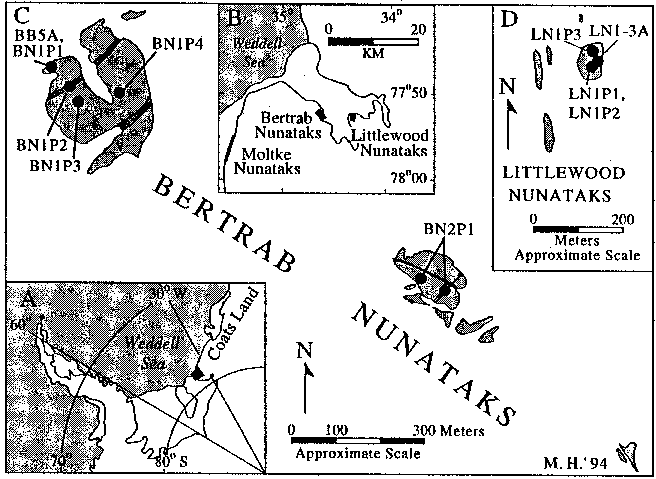 We
mapped and sampled the Bertrab and Littlewood nunataks but were unable to visit
Moltke Nunatak, which is exposed in an ice-fall. Marsh and Thomson (1984)
discuss the confusion over the exact location of the Bertrab Nunataks. Using air
photographs and satellite data, these authors determined the position of the
largest nunatak of the group as 7753'S 3438'W. We confirmed this position using
a hand-held global positioning system device, which was also used to locate and
map the other nunataks of the Bertrab and Littlewood Groups.
We
mapped and sampled the Bertrab and Littlewood nunataks but were unable to visit
Moltke Nunatak, which is exposed in an ice-fall. Marsh and Thomson (1984)
discuss the confusion over the exact location of the Bertrab Nunataks. Using air
photographs and satellite data, these authors determined the position of the
largest nunatak of the group as 7753'S 3438'W. We confirmed this position using
a hand-held global positioning system device, which was also used to locate and
map the other nunataks of the Bertrab and Littlewood Groups.
The Bertrab Nunataks are composed of
red-to-gray weathering, fine- to medium-grained, oligoclase-phyric, isotropic
granophyre, which is cut by flow-banded rhyolite dikes and altered, mafic dikes
(figure 2 C ) (Toubes Spinelli 1983; Marsh and Thomson 1984; Gose et al. 1997).
The five small outcrops of the Littlewood Nunataks (figure 2 D ) are composed of
red-weathering, densely silicified rhyolite (Aughenbaugh, Lounsbury, and
Behrendt 1965). Storey, Pankhurst, and Johnson (1994) report a whole-rock
rubidium-strontium (Rb-Sr) age of 1,076±7 million years for the Bertrab
granophyre and a recalculated whole-rock Rb-Sr age of 976±35 million years for
a mixture of samples from Bertrab and Littlewood nunataks. Aughenbaugh et al.
(1965) report a whole-rock potassium-argon (K-Ar) age of 840±30 million years
for rhyolite at the largest outcrop of the Littlewood Nunataks.
Uranium-lead (U-Pb) isotopic analyses
of two fractions of zircon from the Littlewood rhyolite and two fractions of
titanite from the Bertrab granophyre yield concordant U-Pb ages of 1,112±4
million years and 1,106±3 million years, respectively (Gose et al. 1997). The
ages represent a crystallization age for the rhyolite and a cooling age for the
granophyre. These ages support earlier suggestions of a cogenetic origin for the
granophyre and rhyolite and indicate cooling of the granophyre below the
magnetite Curie Point (580C) by approximately 1.1 billion years ago.
Eighty-four oriented samples were
collected from six sites (four in the granophyre and two in rhyolite dikes) at
the Bertrab Nunataks and three sites in the rhyolite at the Littlewood Nunataks
(figures 2 C and D ). Rock magnetic and petrologic studies indicate that
magnetite is the dominant carrier of magnetic remanence in the Bertrab
granophyre and hematite is the carrier for the Littlewood rhyolite. Site means
of the Bertrab and Littlewood samples are indistinguishable and yield a mean
pole position of 23.9S 258.5E with an error of a95=4.00 (Gose et al. 1997). The
remanent magnetization is interpreted as a primary thermal remanent
magnetization. This interpretation is supported by a lack of evidence for later
thermal resetting (Aughenbaugh et al. 1965; Marsh and Thomson 1984; Gose et al.
1997), as well as a broad similarity of the Coats Land pole position with
paleopoles obtained from approximately 1.0-billion-year-old rocks in Queen Maud
Land (Hodgkinson 1989; Peters 1989) and dissimilarity to poles obtained
from younger rocks in Antarctica (cf. DiVenere, Kent, and Dalziel 1995; Grunow
1995).
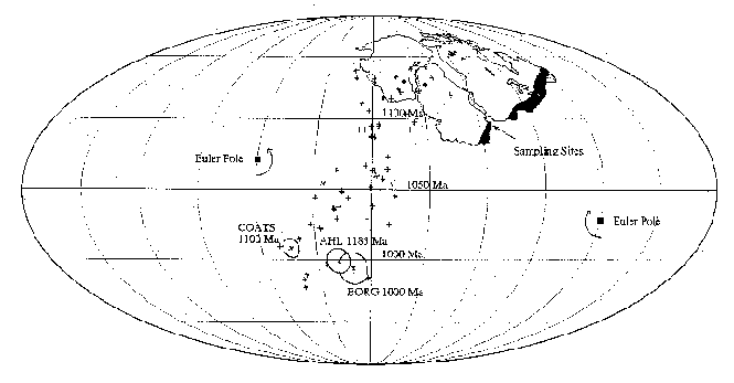
After rotation of the east antarctic
craton about an Euler pole consistent with the SWEAT reconstruction, our new
Coats Land pole falls directly on the Laurentian apparent polar wander path (APWP),
lending support to the Rodinian reconstruction of Dalziel (1991) (figure 3). Our
approximately 1,100-million-year-old Coats Land pole, however, overlaps poles
that define the 1,000-million-year-old segment of the Laurentian APWP.
Uncertainties in the age of magnetization acquisition for both the poles of the
Laurentian APWP and the Coats Land pole may account for this discrepancy.
Shackleton Range
The Shackleton Range is composed of
Paleo- to Mesoproterozoic basement gneisses and granitoids overlain by upper
Neoproterozoic and lower Paleozoic supracrustal rocks (Marsh 1983; Pankhurst,
Marsh, and Clarkson 1983). Concurrent studies of the basement and supracrustal
rocks are underway with the aim of comparing the tectonic history of the range
with equivalent age rocks in the southwestern United States. Our initial efforts
have focused on isotopic and structural studies of basement rocks and a
paleomagnetic study of the overlying Neoproterozoic clastic and carbonate rocks
of the Watts Needle Formation of the Read Mountains in the southern Shackleton
Range.
In the central Read Mountains, the
basement comprises middle amphibolite to granulite-grade gneisses, amphibolites,
and migmatites intruded by variably foliated to unfoliated granitoids (Read
Group; Olesch et al. in press). Foliated but nonmylonitic migmatites and relict
granulites occur north of an east-west striking, south-dipping zone of intense
mylonitization, the Read Mountain Mylonite Zone (RMMZ) (Helper, Grimes, and
Dalziel 1995), that transects the central part of the range. Grain size
reduction textures in quartz and feldspar within mylonites of a variety of
lithologies are consistent with shearing at amphibolite facies conditions.
Subparallel zones of phyllonite and lower temperature mylonite within the
southern portion of the RMMZ indicate renewed or continued motion at greenschist
facies conditions. Both fabrics are cut by subhorizontal to moderately north-dipping,
brittle shears and faults. Maximum ages of mylonitization and dynamic
metamorphism are constrained by new U-Pb zircon ages of approximately 1,790
million years and approximately 1,785 million years (Helper unpublished data)
for a slightly discordant, dioritic layer of mylonitic orthogneiss and a
concordant deformed tonalite dike, respectively. These ages are interpreted as
crystallization ages of the igneous precursors. The tonalite dike is subparallel
to the mylonitic foliation and is boudinaged but not internally foliated,
possibly indicating late-kinematic emplacement. Further U-Pb dating of cross-cutting
dikes and granitoids, as well as high-grade orthogneisses, is presently underway
to constrain the minimum age of ductile deformation and to directly date the
metamorphism.
The Watts Needle Formation is composed
of a lower clastic and upper carbonate unit that rests nonconformably on
Mesoproterozoic granitoids (Marsh 1983). A Vendian age has been assigned on the
basis of acritarchs, stromatolites, and a whole-rock Rb-Sr model age of 720
million years (Golovanov et al. 1979; Pankhurst et al. 1983; Weber 1991). A
detailed study of this unit may enable us to correlate it with other well-studied
Vendian units worldwide (cf. Kirschvink et al. 1991).
We collected oriented samples from both
the granitic basement (31 samples) and overlying Watts Needle Formation (157
samples) at Mount Wegener and Nicol Crags. Samples were drilled at approximately
1.0-meter intervals and 10 or more cores were collected at selected
stratigraphic horizons.
Paleomagnetic results from basal red
siltstones and sandstones of the Watts Needle Formation at Mount Wegener yield a
preliminary mean pole position at 18.5S 44.3E with an a95=7.50 (Hutson, Gose,
and Dalziel 1995). A quartz arenite layer that underlies the upper carbonate
section at Mount Wegener yields a preliminary mean pole position at 4.3S 56.4E
with an a95=11.10 (Hutson et al. 1995). A well-defined component of primary
remanent magnetization for these units was not reset during later tectonic
events (e.g., Ross Orogeny). Evidence for this interpretation includes the
following:
- both normal and reversed polarities
in samples from the quartz arenite unit and
- our pole positions, which are
clearly different from published Early Paleozoic pole positions for the
antarctic craton (cf. Grunow 1995).
Paleopoles from the Watts Needle
Formation fall close to North American paleopoles of similar age after rotation
of East Antarctica into a position adjacent to western North America, as
suggested by the SWEAT hypothesis. The paleomagnetic data from the Watts Needle
Formation support the juxtaposition of the Laurentian and east antarctic cratons
at approximately 750 million years ago.
Paleomagnetic studies of basement rocks
of the Read Mountains and the lower Paleozoic Blaiklock Glacier Group are
underway. Initial results from a conglomerate test in the Blaiklock Glacier
Group suggest that a primary magnetization component may be recovered from these
clastic rocks.
This research is supported by National
Science Foundation grant OPP 91-17996. We thank J. Connelly and Kathy Manser for
assistance and technical support with U-Pb isotopic work.
References
-
Aughenbaugh, N.B., R.W. Lounsbury,
and J.C. Behrendt. 1965. The Littlewood Nunataks, Antarctica. Journal of
Geology , 73(6), 889-894.
-
Dalziel, I.W.D. 1991. Pacific
margins of Laurentia and East Antarctica/Australia as a conjugate rift pair:
Evidence and implications for an Eocambrian supercontinent. Geology , 19(6),
598-601.
-
Dalziel, I.W.D. 1992. Antarctica:
A tale of two supercontinents? Annual Review of Earth and Planetary Sciences
, 20, 501-526.
-
Dalziel, I.W.D., M.A. Helper, F.E.
Hutson, and S.W. Grimes. 1994. Geologic investigations in the Shackleton
Range and Coats Land nunataks, Antarctica. Antarctic Journal of the U.S. ,
29(5), 4-6.
-
DiVenere, V., D.V. Kent, and I.W.D.
Dalziel. 1995. Early Cretaceous paleomagnetic results from Marie Byrd Land,
West Antarctica: Implications for the Weddellia collage of crustal blocks.
Journal of Geophysical Research , 100(B5), 8133-8151.
-
Golovanov, N.P., V.E. Mil'shteyn,
V.M. Mikhaylov, and O.G. Shulyatin. 1979. Stromatoliths and microphytoliths
of the Shackleton Range (western Antarctica). Doklady Akademii Nauk , SSSR.
249(4), 977-979. [In Russian]
-
Gose, W.A., I.W.D. Dalziel, M.A.
Helper, F.E. Hutson, and J.N. Connelly. 1997. Paleomagnetic data and U-Pb
isotopic ages from Coats Land, Antarctica: A test of the Laurentian-East
Antarctic ("SWEAT") connection. Journal of Geophysical Research ,
102(B4), 7887-7902.
-
Grunow, A.M. 1995. Implications
for Gondwana of new Ordovician paleomagnetic data from igneous rocks in
southern Victoria Land, East Antarctica. Journal of Geophysical Research ,
100(B7), 12589-12603.
-
Helper, M.A., S.W. Grimes, and
I.W.D. Dalziel. 1995. Basement-cover relations and fabrics of the central
Read Mountains, Shackleton Range, Antarctica. Seventh International
Symposium on Antarctic Earth Sciences, Siena, Italy. [Abstract]
-
Hodgkinson, G.R. 1989.
Palaeomagnetic studies in western Dronning Maud Land, Antarctica. (Unpublished
Masters of Science thesis, Department of Geophysics, University of
Witwatersrand, Republic of South Africa.)
-
Hutson, F.E., W.A. Gose, and I.W.D.
Dalziel. 1995. Paleomagnetic results from the Neoproterozoic Watts Needle
Formation, Shackleton Range, Antarctica. Seventh International Symposium on
Antarctic Earth Sciences, Siena, Italy. [Abstract]
-
Kirschvink, J.L., M. Magaritz, R.L.
Ripperdan, A.Yu. Zhuravlev, and A.Yu. Rozanov. 1991. The Precambrian/Cambrian
boundary: Magnetostratigraphy and carbon isotopes resolve correlation
problems between Siberia, Morocco, and South China. GSA Today , 1(4), 69-71,
87, 91.
-
Marsh, P.D. 1983. The Late
Precambrian and Early Paleozoic history of the Shackleton Range, Coats Land.
In R.L. Oliver, P.R. James, and J.B. Jago (Eds.), Antarctic earth science .
Canberra: Australian Academy of Science.
-
Marsh, P.D., and J.W. Thomson.
1984. Location and geology of nunataks in north-western Coats Land. British
Antarctic Survey Bulletin , 65, 33-39.
-
Moores, E.M. 1991. The Southwest
U.S.-East Antarctica (SWEAT) connection: A hypothesis. Geology , 19(5),
425-428.
-
Moyes, A.B., J.M. Barton, Jr., and
P.B. Groenewald. 1993. Late Proterozoic to Early Paleozoic tectonism in
Dronning Maud Land, Antarctica: Supercontinental fragmentation and
amalgamation. Journal of the Geological Society London , 150, 833-842.
-
Olesch, M., H.M. Braun, E.N.
Kamenev, G.I. Kamenev, and W. Schubert. In press. Read Group. In J.W.
Thomson (Ed.), British Antarctic Survey Geomap 4 .
-
Pankhurst, R.J., P.D. Marsh, and
P.D. Clarkson. 1983. A geochronological investigation of the Shackleton
Range. In R.L. Oliver, P.R. James, and J.B. Jago (Eds.), Antarctic earth
science . Canberra: Australian Academy of Science.
-
Peters, M. 1989. Igneous rocks in
western and central Neuschwabenland, Vestfjella and Ahlmannryggen,
Antarctica: Petrography, geochemistry, geochronology, paleomagnetism,
geotectonic implications. Berichte zur Polarforschung (Vol. 61). Bremerhaven,
Germany: Alfred-Wegener-Institute for Polar and Marine Research.
-
Storey, B.C., R.J. Pankhurst, and
A.C. Johnson. 1994. The Grenville Province within Antarctica: A test of the
SWEAT hypothesis. Journal of the Geological Society London , 151, 1-4.
-
Toubes Spinelli, R.O. 1983.
Geology of the Bertrab Nunatak, Argentinian sector of Antarctica.
Contribucion Instituto Antarctico Argentino , 296, 1-9. [In Spanish]
-
Weber, K. 1991. Microfossils in
Proterozoic sediments from the Southern Shackleton Range, Antarctica: A
preliminary report. Zeitschrift für Geologie Wissenschaft , 19(2), 185-197.
Reprinted from the December 1997
online issue of Antarctic Journal of the United States (volume 32, number 4).
Cambrian magmatic rocks of the Ellsworth
Mountains, West Antarctica
MARGARET N. REES, EUGENE I. SMITH, and DEBORAH L.
KEENAN, Department of Geoscience, University of Nevada, Las Vegas, Nevada 89154
ERNEST M. DUEBENDORFER, Department of Geology, Northern Arizona University,
Flagstaff, Arizona 86011
A critical element in reconstructing the paleo-Pacific margin of
Gondwanaland is the Ellsworth-Whitmore mountains terrane that lies between the
Transantarctic Mountains and Antarctic Peninsula (Storey et al. 1988).
Paleomagnetic data suggest that during the Cambrian, the terrane lay near the
juncture of Africa and Antarctica (Grunow 1995). Nevertheless, much of the
tectonic history of this terrane is equivocal and numerous conflicting models
have been proposed regarding its tectonic setting and timing of magmatism (Vennum
et al. 1992; Grunow 1995; Curtis and Storey 1996; Dalziel 1997). Thus, one
aspect of our larger Ellsworth Mountains project focused on the geochemistry and
geochronology of magmatic rocks in the northern Heritage Range of the Ellsworth
Mountains. We conducted fieldwork during the 1996-1997 austral summer and
subsequently completed laboratory analyses. The Cambrian Heritage Group is composed of volcanic and sedimentary rocks (figure
2) (Webers et al. 1992) that are unconformably overlain by the Ordovician(?)-Devonian
siliciclastic Crashsite Group (Duebendorfer and Rees in press). The dominant
structures in the range, which are attributed to the Triassic Ellsworth/Gondwanide
Orogeny, are north-northwest-trending folds and a series of east-vergent stacked
thrust sheets that have disrupted the stratigraphic succession. In addition, the
Heritage Group preserves evidence of an earlier pre-Crashsite Group deformation
that is attributed to deformation within the Ross orogen (Duebendorfer and Rees
in press).
The Cambrian Heritage Group is composed of volcanic and sedimentary rocks (figure
2) (Webers et al. 1992) that are unconformably overlain by the Ordovician(?)-Devonian
siliciclastic Crashsite Group (Duebendorfer and Rees in press). The dominant
structures in the range, which are attributed to the Triassic Ellsworth/Gondwanide
Orogeny, are north-northwest-trending folds and a series of east-vergent stacked
thrust sheets that have disrupted the stratigraphic succession. In addition, the
Heritage Group preserves evidence of an earlier pre-Crashsite Group deformation
that is attributed to deformation within the Ross orogen (Duebendorfer and Rees
in press).
Volcanic rocks within the dominantly sedimentary succession of the Heritage
Group are present in the Union Glacier and Springer Peak formations (figure 2) (Webers
et al. 1992). In the Union Glacier Formation, basalt to andesite hyaloclastite
deposits, and flows and interbedded sedimentary rocks locally are cut by dikes
of basalt. The hyaloclastite deposits have yielded uranium/lead (U/Pb) zircon
ages of 512±14 million years (Van Schmus personal communication). This date,
together with other stratigraphic data (Duebendorfer and Rees in press) and the
timescale of Shergold (1995), suggests deposition during the late Early Cambrian
or early Middle Cambrian.
 The
Union Glacier volcanic rocks are subalkaline, tholeittic basalt and picritic
basalt with 50 to 62 weight percent silica (SiO2). Alumina (Al2O3),
titania (TiO2), ferric iron (FeO), lime (CaO), magnesia (MgO), and
soda (Na2O) decrease with increasing SiO2. Their magnesium
number (Mg#; magnesium divided by the sum of magnesium plus iron) varies from 42
to 65. These rocks are enriched in light rare earth elements (LREE) when
compared to chondritic abundances (60-200x) and display negative niobium (Nb),
tantalum (Ta), and titanium (Ti) anomalies. Epsilon neodymium (Nd) varies from
+2 to -1, and initial strontium-87/strontium-86 (87Sr/86Sr)
between 0.7043 and 0.7095. Their geochemistry is very similar to that of mid-oceanic
ridge basalt from the Gulf of California (Saunders et al. 1982), and they have
trace element abundances reflecting asthenospheric and lithospheric mantle and
crustal components. Nd model ages of 0.9 to 1.0
billion years from the Union Glacier volcanic rocks (Walker personal
communication) may suggest the age of the underlying lithosphere of the newly
formed narrow ocean basin
The
Union Glacier volcanic rocks are subalkaline, tholeittic basalt and picritic
basalt with 50 to 62 weight percent silica (SiO2). Alumina (Al2O3),
titania (TiO2), ferric iron (FeO), lime (CaO), magnesia (MgO), and
soda (Na2O) decrease with increasing SiO2. Their magnesium
number (Mg#; magnesium divided by the sum of magnesium plus iron) varies from 42
to 65. These rocks are enriched in light rare earth elements (LREE) when
compared to chondritic abundances (60-200x) and display negative niobium (Nb),
tantalum (Ta), and titanium (Ti) anomalies. Epsilon neodymium (Nd) varies from
+2 to -1, and initial strontium-87/strontium-86 (87Sr/86Sr)
between 0.7043 and 0.7095. Their geochemistry is very similar to that of mid-oceanic
ridge basalt from the Gulf of California (Saunders et al. 1982), and they have
trace element abundances reflecting asthenospheric and lithospheric mantle and
crustal components. Nd model ages of 0.9 to 1.0
billion years from the Union Glacier volcanic rocks (Walker personal
communication) may suggest the age of the underlying lithosphere of the newly
formed narrow ocean basin
Pillow basalt and flows cut by diabase and gabbro dikes and sills are present
in the Springer Peak Formation (figure 2). Locally, isolated basalt flow lobes
are interbedded with latest Middle Cambrian fossiliferous shale and limestone
that indicate mafic magmatism continued in the region until approximately 500
million years ago, using the timescale of Shergold (1995).
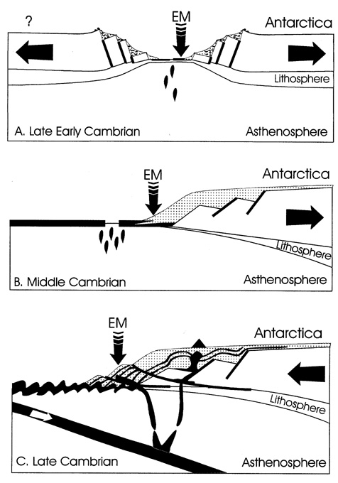
Springer Peak Formation volcanic rocks are subalkaline, calc-alkalic basalt,
andesite, and trachyandesite with 37 to 50 percent SiO2. Al2O3,
TiO2, and CaO decrease with increasing SiO2. Their Mg#
varies from 42 to 65. These rocks have low rubidium (Rb), potassium (K), and Sr
due to alteration and lack high field strength element (Nb, Ta) anomalies when
normalized to primitive mantle. They are moderately enriched in LREE (40-80x
chondrite), have an epsilon Nd of +5, and initial 87Sr/86Sr
of 0.705. The basalt is similar to enriched mid-oceanic ridge basalt (MORB)
although their higher barium (Ba) and Sr may suggest either source heterogeneity,
alteration, or minor sediment input. We suggest that they erupted in an ocean
basin wider than that represented by Union Glacier volcanics and in which the
lithospheric mantle had been delaminated (figure 3 B ).
Dacite and rhyolite sills and dikes were observed in the Springer Peak
Formation on Yochelson Ridge in the Heritage Range. These rocks, however, have
yielded zircon U/Pb dates of 4986 million years (Van Schmus personal
communication). Again using the timescale of Shergold (1995), these rocks could
represent a Late Cambrian magmatic episode that postdated the Springer Peak
Formation and predated deposition of the Crashsite Group.
These intrusions are calc-alkaline dacite and rhyolite with SiO2
content between 75 to 87 percent SiO2, and Mg# between 22 and 40.
They are enriched in large-ion lithophile elements (LIL) and LREE (500x
chondrite) but depleted in Ba and Sr. They have negative anomalies at Nb and
zirconium (Zr), a very strong negative anomaly at Ti when compared to primitive
mantle, and distinct negative europium (Eu) anomaly compared to chondrite.
Epsilon Nd is +0.5 and intitial 87Sr/86Sr is 0.713.
Tectonic discrimination diagrams suggest that the dacite and rhyolite intrusives
formed in a continental arc setting. Furthermore, the geochemical and isotopic
differences preclude these more felsic rocks of Yochelson Ridge from being
produced by fractional crystallization of magmas that produced the mafic
succession in the Springer Peak. Thus, the later felsic rocks represent closing
of the narrow ocean basin and onset of subduction related magmatism (figure 3
C ).
Our geochemical and geochronological study of the Union Glacier and Springer
Peak formations of the Heritage Group in the Ellsworth Mountains indicates
opening of a narrow ocean basin during late Early through Middle Cambrian time.
The subsequent Late Cambrian arc magmatism together with deformation and low-grade
metamorphism of the Heritage Group and the angular unconformity at the base of
the overlying Crashsite Group are compelling evidence that the Ellsworth-Whitmore
mountains terrane lay within the Cambrian mobile belts of the paleo-Pacific-facing
margin of Gondwanaland.
This research was supported by National Science Foundation grants OPP
92-20395 and OPP 93-12040.
References
- Curtis, M.L., and B.C. Storey. 1996. A review of geological constraints on
the pre-break-up position of the Ellsworth Mountains within Gondwana:
Implications for Weddell Sea evolution. In B.C. Storey, E.C. King, and R.A.
Livermore (Eds.), Weddell Sea tectonics and Gondwana break-up. London:
The Geological Society.
- Dalziel, I.W.D. 1997. Neoproterozoic-Paleozoic geography and tectonics:
Review, hypothesis, environmental speculation. Geological Society of
America Bulletin , 109(1), 16-42.
- Duebendorfer, E.M., and M.N. Rees. In press. Evidence for Cambrian
deformation in the Ellsworth-Whitmore mountains terrane, Antarctica:
Stratigraphic and tectonic implications. Geology .
- Grunow, A.M. 1995. Implications for Gondwana of new Ordovician
paleomagnetic data from igneous rocks in southern Victoria Land, East
Antarctica. Journal of Geophysical Research , 100(B7), 12589-12603.
- Saunders, A.D., D.J. Fornari, J.L. Joron, J. Tarney, and M. Trevil. 1982.
Geochemistry of basic igneous rocks, Gulf of California. In Deep Sea
Drilling Project Leg 64. Washington D.C.: U.S. Government Printing
Office.
- Shergold, J.H. 1995. Timescales 1. Cambrian. In Australian Phanerozoic
timescales biostratigraphic charts and explanatory notes (second
series). Canberra, Australia: Australian Geological Survey Organisation.
- Storey, B.C., I.W.D. Dalziel, S.W. Garrett, A.M. Grunow, R.J. Pankhurst,
and W.R. Vennum. 1988. West Antarctica in Gondwanaland: Crustal blocks,
reconstruction and break-up processes. Tectonophysics , 155, 381-390.
- Van Schmus, W.R. 1997. Personal communication.
- Vennum, W.R., P. Gizycki, V.V. Samsonov, A.G. Markovich, and R.J.
Pankhurst. 1992. Igneous petrology and geochemistry of the southern Heritage
Range, Ellsworth Mountains, West Antarctica. In G.F. Webers, C. Craddock,
and J.F. Splettsoesser (Eds.), Geology and paleontology of the Ellsworth
Mountains, West Antarctica. Boulder: Geological Society of America.
- Walker, J.D. 1997. Personal communication.
- Webers, G.F., R.L. Bauer, J.M. Anderson, W. Buggisch, R.W. Ojakangas, and
K.B. Sporli. 1992. The Heritage Group of the Ellsworth Mountains, West
Antarctica. In G.F. Webers, C. Craddock, and J.F. Splettsoesser (Eds.), Geology
and paleontology of the Ellsworth Mountains, West
Antarctica. Boulder: Geological Society of America.
Tomado de Antarctic Journal of the United States Review 1997. Marine and
Terrestrial Geology and Geophysics
CICLO
TRANSAMAZONIANO DEL CRATON DEL RIO DE LA PLATA
CICLO
URUGUAYANO DEL CRATON DE LA ANTARTIDA ORIENTAL
Cátedra de Geología Argentina
INICIO
CURSO 2006